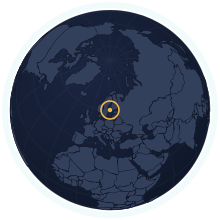
Åland Islands at its true size
Åland Islands covers 1,583 km², number 182 of 235 countries and territories by area. Home to 30,836 people (2025). A Mercator map draws it about 4.05× too large.
Equal-area projection · Natural Earth 50m
| Area | 1,583 km² Wikidata |
|---|---|
| Population | 30,836 Wikidata, 2025 |
| Density | 19 per km² |
| Capital | Mariehamn |
| Local time in Mariehamn | |
| Time zone | UTC+2, summer time UTC+3 IANA |
| Currency | Euro (EUR) Wikidata |
| Languages | Swedish |
| Traffic | On the right |
| Region | Northern Europe, Europe |
| Status | Territory of Finland |
| Coast | Has a coastline |
| Calling code | +358 18 |
| Codes | AX · ALA · 248 |
Weather in Mariehamn now
Now
—Loading the forecast…
The next three days
Weather data: MET Norway (CC BY 4.0), updated hourly · Temperatures on the map
Countries of a similar size
Every country within 25% of the Åland Islands’s area, lit up on the map →
- Comoros0.78×Åland Islands is 22% smaller than Comoros.
- Mauritius0.78×Åland Islands is 22% smaller than Mauritius.
- São Tomé and Principe1.58×Åland Islands is 58% larger than São Tomé and Principe.
- Luxembourg0.61×Åland Islands is 39% smaller than Luxembourg.
- Samoa0.56×Åland Islands is 44% smaller than Samoa.
- Kiribati1.95×Åland Islands is 95% larger than Kiribati.
How many times does Åland Islands fit into…
- Russia: about 10787 times
- Canada: about 6307 times
- United States: about 6208 times
Questions about Åland Islands
- How big is Åland Islands?
- Åland Islands covers 1,583 km², which makes it number 182 of 235 countries and territories by area. About 30,836 people live there (2025), 19 per km².
- Is Åland Islands bigger than Comoros?
- Åland Islands is 22% smaller than Comoros. Åland Islands: 1,583 km²; Comoros: 2,034 km².
- How much does the Mercator map distort Åland Islands?
- At about 60° latitude, Mercator stretches Åland Islands to roughly 4.05× its true area relative to a country on the equator. Kartavera draws it in the Equal Earth projection, where areas are exact.
- Does Åland Islands have land borders?
- No. Åland Islands has no land neighbours; every border is a coastline.