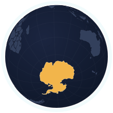
Antarctica at its true size
Antarctica covers 14,000,000 km², number 2 of 235 countries and territories by area. Home to 4,400 people (2009). A Mercator map draws it about 129× too large.
Equal-area projection · Natural Earth 50mRemote islands and overseas parts not drawn; the figures include them
| Area | 14,000,000 km² Wikidata |
|---|---|
| Population | 4,400 Wikidata, 2009 |
| Density | 0.00 per km² |
| Capital | — |
| Time zone | UTC+3 · UTC−3 to UTC+12, 8 time zones IANA |
| Currency | — |
| Languages | — |
| Traffic | — |
| Region | Antarctica, Antarctica |
| Status | Governed under the Antarctic Treaty |
| Coast | Has a coastline |
| Calling code | — |
| Codes | AQ · ATA · 010 |
Countries of a similar size
Every country within 25% of Antarctica’s area, lit up on the map →
- Russia0.82×Antarctica is 18% smaller than Russia.
- Canada1.4×Antarctica is 40% larger than Canada.
- United States1.42×Antarctica is 42% larger than United States.
- China1.46×Antarctica is 46% larger than China.
- Brazil1.64×Antarctica is 64% larger than Brazil.
- Australia1.82×Antarctica is 82% larger than Australia.
Questions about Antarctica
- How big is Antarctica?
- Antarctica covers 14,000,000 km², which makes it number 2 of 235 countries and territories by area. About 4,400 people live there (2009), 0.00 per km².
- Is Antarctica bigger than Russia?
- Antarctica is 18% smaller than Russia. Antarctica: 14,000,000 km²; Russia: 17,075,400 km².
- How much does the Mercator map distort Antarctica?
- At about 85° latitude, Mercator stretches Antarctica to roughly 129× its true area relative to a country on the equator. Kartavera draws it in the Equal Earth projection, where areas are exact.
- Does Antarctica have land borders?
- No. Antarctica has no land neighbours; every border is a coastline.