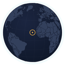
Cabo Verde at its true size
Cabo Verde covers 4,033 km², number 166 of 194 countries by area. Home to 527,326 people (2025). Sitting near the equator, it is one of the few places Mercator gets almost right.
Equal-area projection · Natural Earth 50m
| Area | 4,033 km² Wikidata |
|---|---|
| Population | 527,326 World Bank, 2025 |
| Density | 131 per km² |
| Capital | Praia |
| Local time in Praia | |
| Time zone | UTC−1 IANA |
| Currency | Cape Verdean escudo (CVE) Wikidata |
| Languages | Portuguese, Cape Verdean Creole |
| Traffic | On the right |
| Region | Western Africa, Africa |
| Status | Independent state |
| Coast | Has a coastline |
| Calling code | +238 |
| Codes | CV · CPV · 132 |
Weather in Praia now
Now
—Loading the forecast…
The next three days
Weather data: MET Norway (CC BY 4.0), updated hourly · Temperatures on the map
Where Cabo Verde ranks
Among the independent states, in 43 rankings. Each links to its table.
People
- Population#168 of 194527,326 people#52 of 54 in Africa
- Population density#69 of 194131 people per km²#13 of 54 in Africa
- Urban population#51 of 19278% urban#3 of 54 in Africa
- Fertility rate#135 of 1921.51 births per woman#53 of 54 in Africa
- Population growth#128 of 192+0.47% a year#53 of 54 in Africa
- Birth rate#110 of 19212.2 births per 1,000 people#52 of 54 in Africa
- Death rate#168 of 1925.1 deaths per 1,000 people#52 of 54 in Africa
- Children under 15#92 of 19224.7% under 15#51 of 54 in Africa
- People over 65#99 of 1927.2% aged 65 and over#5 of 54 in Africa
- Net migration#153 of 192−2.4 per 1,000 people#47 of 54 in Africa
- Refugees abroad#138 of 1900.03 refugees abroad per 1,000 people#46 of 54 in Africa
Health & education
Economy
- GNI per capita#109 of 185$5,590 a person#9 of 52 in Africa
- Internet users#109 of 18475% online#7 of 52 in Africa
- GDP per capita (PPP)#120 of 184$12,165 a person#12 of 52 in Africa
- GDP growth#26 of 187+6.3% a year#11 of 52 in Africa
- Inflation#109 of 176+2.3% a year#34 of 50 in Africa
- Unemployment#26 of 17811.9% of the labour force#14 of 53 in Africa
- Extreme poverty#41 of 14914.6% under $3.00 a day#37 of 47 in Africa
- Income inequality (Gini)#27 of 149a Gini index of 42.4#14 of 47 in Africa
- Jobs in agriculture#112 of 1789.2% of jobs#50 of 53 in Africa
- Jobs in industry#54 of 17823.1% of jobs#7 of 53 in Africa
- Jobs in services#61 of 17867.7% of jobs#5 of 53 in Africa
- Foreign investment#37 of 1845.0% of GDP#12 of 52 in Africa
- Exports#63 of 16842.0% of GDP#13 of 49 in Africa
- Military spending#135 of 1550.7% of GDP#42 of 50 in Africa
- Mobile subscriptions#107 of 191112 subscriptions per 100 people#20 of 54 in Africa
Energy & environment
- CO₂ per person#120 of 1851.29 tonnes a person#13 of 53 in Africa
- Forest area#140 of 19213% forest#34 of 54 in Africa
- Renewable energy#100 of 19021.8% renewable#44 of 54 in Africa
- Access to electricity#117 of 19298.4% with electricity#7 of 54 in Africa
- Air pollution (PM2.5)#80 of 19120.2 µg/m³#34 of 54 in Africa
- Protected land#96 of 19117.6% of the land protected#23 of 54 in Africa
- Arable land#59 of 19018.0% of the land arable#17 of 54 in Africa
- Water stress#29 of 17659.7% of its available fresh water#8 of 53 in Africa
- Precipitation#161 of 180228 mm a year#47 of 54 in Africa
Governance & safety
Countries of a similar size
Every country within 25% of Cabo Verde’s area, lit up on the map →
- Trinidad and Tobago0.79×Cabo Verde is 21% smaller than Trinidad and Tobago.
- Samoa1.42×Cabo Verde is 42% larger than Samoa.
- Brunei0.7×Cabo Verde is 30% smaller than Brunei.
- Luxembourg1.56×Cabo Verde is 56% larger than Luxembourg.
- Mauritius1.98×Cabo Verde is 98% larger than Mauritius.
- Comoros1.98×Cabo Verde is 98% larger than Comoros.
How many times does Cabo Verde fit into…
- Russia: about 4234 times
- Canada: about 2476 times
- United States: about 2437 times
Questions about Cabo Verde
- How big is Cabo Verde?
- Cabo Verde covers 4,033 km², which makes it number 166 of 194 countries by area. About 527,326 people live there (2025), 131 per km².
- Is Cabo Verde bigger than Trinidad and Tobago?
- Cabo Verde is 21% smaller than Trinidad and Tobago. Cabo Verde: 4,033 km²; Trinidad and Tobago: 5,128 km².
- How much does the Mercator map distort Cabo Verde?
- Cabo Verde lies close to the equator, so Mercator draws it at nearly its true size. It is the countries far from the equator that Mercator inflates.
- Does Cabo Verde have land borders?
- No. Cabo Verde has no land neighbours; every border is a coastline.