Saint Vincent and the Grenadines at its true size
Saint Vincent and the Grenadines covers 389 km², number 184 of 194 countries by area. Home to 99,924 people (2025). Sitting near the equator, it is one of the few places Mercator gets almost right.
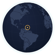
| Area | 389 km² Wikidata |
|---|---|
| Population | 99,924 World Bank, 2025 |
| Density | 257 per km² |
| Capital | Kingstown |
| Local time in Kingstown | |
| Time zone | UTC−4 IANA |
| Currency | Eastern Caribbean dollar (XCD) Wikidata |
| Languages | English |
| Traffic | On the left |
| Region | Caribbean, North America |
| Status | Independent state |
| Coast | Has a coastline |
| Calling code | +1 784 |
| Codes | VC · VCT · 670 |
Weather in Kingstown now
Weather data: MET Norway (CC BY 4.0), updated hourly · Temperatures on the map
Where Saint Vincent and the Grenadines ranks
Among the independent states, in 39 rankings. Each links to its table.
People
- Population#183 of 19499,924 people#20 of 23 in North America
- Population density#39 of 194257 people per km²#8 of 23 in North America
- Urban population#132 of 19248% urban#18 of 23 in North America
- Fertility rate#112 of 1921.76 births per woman#10 of 23 in North America
- Population growth#185 of 192−0.69% a year#23 of 23 in North America
- Birth rate#112 of 19212.0 births per 1,000 people#10 of 23 in North America
- Death rate#21 of 19211.5 deaths per 1,000 people#2 of 23 in North America
- Children under 15#111 of 19220.9% under 15#10 of 23 in North America
- People over 65#69 of 19212.3% aged 65 and over#9 of 23 in North America
- Net migration#177 of 192−7.1 per 1,000 people#23 of 23 in North America
- Refugees abroad#44 of 1901.94 refugees abroad per 1,000 people#8 of 23 in North America
Health & education
- Life expectancy#121 of 19271.4 years#21 of 23 in North America
- Infant mortality#111 of 19110.2 infant deaths per 1,000 live births#15 of 23 in North America
- University enrolment#89 of 14541.5% gross enrolment#8 of 15 in North America
- Human Development Index#75 of 190an index of 0.798#10 of 23 in North America
Economy
- GNI per capita#75 of 185$12,000 a person#12 of 22 in North America
- Internet users#108 of 18476% online#12 of 23 in North America
- GDP per capita (PPP)#83 of 184$22,799 a person#13 of 22 in North America
- GDP growth#89 of 187+3.4% a year#9 of 23 in North America
- Inflation#147 of 176+0.8% a year#17 of 22 in North America
- Unemployment#10 of 17818.0% of the labour force#1 of 19 in North America
- Jobs in agriculture#114 of 1789.1% of jobs#12 of 19 in North America
- Jobs in industry#70 of 17821.1% of jobs#6 of 19 in North America
- Jobs in services#53 of 17869.8% of jobs#9 of 19 in North America
- Foreign investment#21 of 1848.9% of GDP#3 of 23 in North America
- Mobile subscriptions#114 of 191108 subscriptions per 100 people#12 of 23 in North America
Energy & environment
- CO₂ per person#119 of 1851.31 tonnes a person#17 of 23 in North America
- Forest area#12 of 19273% forest#2 of 23 in North America
- Renewable energy#158 of 1905.1% renewable#19 of 23 in North America
- Access to electricity#1 of 192100.0% with electricity#1 of 23 in North America
- Air pollution (PM2.5)#151 of 19110.6 µg/m³#16 of 23 in North America
- Protected land#64 of 19122.6% of the land protected#8 of 23 in North America
- Arable land#130 of 1905.1% of the land arable#18 of 23 in North America
- Water stress#101 of 1767.9% of its available fresh water#14 of 22 in North America
- Precipitation#52 of 1801,583 mm a year#13 of 23 in North America
Governance & safety
Countries of a similar size
Every country within 25% of Saint Vincent and the Grenadines’s area, lit up on the map →
- Grenada1.11×Saint Vincent and the Grenadines is 11% larger than Grenada.
- Barbados0.89×Saint Vincent and the Grenadines is 11% smaller than Barbados.
- Antigua and Barbuda0.88×Saint Vincent and the Grenadines is 12% smaller than Antigua and Barbuda.
- Seychelles0.85×Saint Vincent and the Grenadines is 15% smaller than Seychelles.
- Palau0.83×Saint Vincent and the Grenadines is 17% smaller than Palau.
- Andorra0.83×Saint Vincent and the Grenadines is 17% smaller than Andorra.
How many times does Saint Vincent and the Grenadines fit into…
- Russia: about 43896 times
- Canada: about 25668 times
- United States: about 25261 times
The land itself
Rivers, summits and lakes Saint Vincent and the Grenadines shares with the rest of the world. Turn on “Rivers & lakes” and “Physical names” in the atlas to see them on the map.
- La Soufrière1,220 m
Rivers are listed by the published length of their whole course, not the part inside Saint Vincent and the Grenadines. Figures from Wikidata, features from Natural Earth.
Questions about Saint Vincent and the Grenadines
- How big is Saint Vincent and the Grenadines?
- Saint Vincent and the Grenadines covers 389 km², which makes it number 184 of 194 countries by area. About 99,924 people live there (2025), 257 per km².
- Is Saint Vincent and the Grenadines bigger than Grenada?
- Saint Vincent and the Grenadines is 11% larger than Grenada. Saint Vincent and the Grenadines: 389 km²; Grenada: 349 km².
- How much does the Mercator map distort Saint Vincent and the Grenadines?
- Saint Vincent and the Grenadines lies close to the equator, so Mercator draws it at nearly its true size. It is the countries far from the equator that Mercator inflates.
- Does Saint Vincent and the Grenadines have land borders?
- No. Saint Vincent and the Grenadines has no land neighbours; every border is a coastline.